bigpoppa
Well-known member
all the weight is on the front, and the clipons are low so it turned on a dime, but my upper body hated itAt least 3 hours out of the 8 is stretching on the roadside and positive affirmations to myself, to keep going lol
all the weight is on the front, and the clipons are low so it turned on a dime, but my upper body hated itAt least 3 hours out of the 8 is stretching on the roadside and positive affirmations to myself, to keep going lol
rode up to owen sound area for no particular reason


Hilarious, must see that next time I am up that way.rode up to owen sound area for no particular reason

Not gonna lie, every time I see a picture of your bike, I imagine you also carrying a bottle of windex and a microfibre cloth in a backpack or pannier everywhere you go.
Or this:

Nice ride and beautiful pictures! You have some discipline for not eating those pierogiesYesterday's ride up to Muskoka.
Thanks to @jdmsteR for letting me know about Port Sydney and Huntsville lookout, great suggestions.
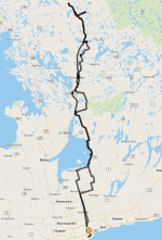
The route was pretty simple, mostly to hit up those destinations, and other stops along the way. The one exception was HWY 46 from 117 to HWY 10. At first it was great, then I hit this long stretch of construction. It wasn't even gravel it was dirt and muck, because they were in the process of grading it. Not fun, bit slippery in spots.
I've been through Gravenhurst and Bracebridge a few times but never really looked around, found some stuff I didn't notice before will have to go back and explore some more.
Here is how it went
View attachment 50246
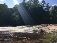
Falls in Port Sydney
View attachment 50247
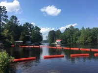
Opposite side of the falls is quite picturesque
View attachment 50248
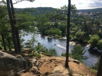
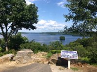
Huntsville Lookout over the river side
View attachment 50249
Other side of lookout view of Fairy Lake
View attachment 50250
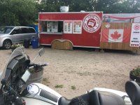
Burk Falls, why not, and to see this Food Truck as mentioned by @Evoex @mimico_polak
Actually the girl at the Shell asked me why the heck I came all this way to Burk Falls
View attachment 50252
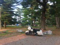
On the way back home, stop in Gravenhurst.
View attachment 50251
Thank you for this!! Seriously.Nice ride and beautiful pictures! You have some discipline for not eating those pierogies
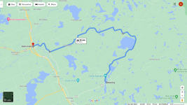
If you have the time the next time you are up that way, continue heading east from Kearney, and it will loop up to Chetwynd Rd and over to Burks Falls. It's a bit nicer than going back and up the Hwy 11 without adding too much time onto your day. Something like:
View attachment 50253
It's great that you're able to stop and enjoy the place for a bit.Falls in Port Sydney
Opposite side of the falls is quite picturesque
Huntsville Lookout over the river side
Other side of lookout view of Fairy Lake
On the way back home, stop in Gravenhurst.
The first time I took Chetwynd it was for the reason you just described - just to see what was over there. I didn't have a GPS back then, but I had a backroads mapbook and wrote out turn by turn directions slipped into my tankbag. About 5 or 7 years ago the road was in really great shape and there was zero traffic. I haven't been on it in a few years, so hopefully it's still in good shape.Thank you for this!! Seriously.
Every time I explore around Kearney on Google Maps I see a more defined highway with this half loop, and tell myself I will do this once I am up that way. Once I get there I can't figure it out. I use MapsME on my phone and it's not as clearly noticeable, for day trips I don't plan a route and upload to GPS either. I may have to in this case!
Usually I take HWY 592 between Novar and Burk Falls, it's a nice quiet road between the trees. That area smells so fresh, pine etc.
For your bike if you don't mind doing some light gravel, then there are some really sweet fire roads and logging roads to check out. I did a ride out that way to explore the west side of Algonquin and all those roads are posted here: Gravel and Forest RoadsI’ll trailer my bike up to Kearney next time as we’ve got friends with cottages there. Beautiful area.


Absolutely my favourite place for swimming.Awenda Park this morning:


Our family cottage (where my Mom now lives full time) is just around the corner from Awenda. We used to have about 100 ft of sandy beach, but rising water levels over the last 10 years have reduced it to about 15ft. But at least the air and water are really clean. Love it up here - just wish there was some twisty roads!Absolutely my favourite place for swimming.
Have been going since it opened

Awesome pics.It's summertime and the Okanagan is on fire again. It's pretty bad this year because of the unusually high temperatures coupled with the normally scarce rainfall. Winds are non-existent which is both a good thing and a bad thing. Good, because it's helping stop the spread of wildfires, but bad because there's a permanent cloud of smoke which is hanging all over the valley - a 1,500 km cloud stretching from Idaho State all the way up to Prince George.
We still manage to make it outside for our day rides, but the second we step out the front door, the air smells like a campfire. Ash continuously falls slowly from the sky, and the black of our seats quickly become covered with grey summer snow. It's difficult to tell what time of day it is because wildfire smoke has turned the sun into a hazy, red ball hanging in the air like a faded Christmas ornament.


This was 7:30AM.
Yeah it's pretty crazy, I have friends in PG, and they can't escape it as soon as you go outside it impacts you. Kinda surprised it hasn't rained yet.It's summertime and the Okanagan is on fire again.

