Iron Butt routes | GTAMotorcycle.com

Iron Butt routes

NuggyBuggy

Well-known member
Site Supporter
I've had doing an IB on my bucket list for a long time. I have the week off, kids are in the city with Mom, and the weather is nice, so I thought about doing one. I know that fall is less ideal because of the shorter days, but no time like the present.

I'm in the Orillia area. I'm assuming the best way to do this would be to get on the 401 so I could max out time and distance spent with traffic at 120+. I have never used the 407 but it looks like it would be a great time saver as opposed to going through the 401 during - well, anytime.

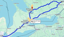
I thought about going south,heading west to Windsor area, then U-turn, head east where I can to Ottawa, then back to start, using 407 where I can.


This puts me at just over 1600km which is tight.
Screenshot 2024-10-21 at 12.07.26 PM.png

Thoughts or suggestions (routes, times, etc)? I thought maybe going back along 401/407 on the back leg from Ottawa then North might allow me to pad my average speed?

I only picked these end points based on my limited knowledge of highways outside the GTA and am willing to change anything here.
 
@mimico_polak might have done a 401 run. I think @PrivatePilot did too with a thread on it.

407 is good for average speed but end to end is about $75 in each direction. I'd probably run waze and schedule so I go through toronto between 01:00 and 04:00. I don't like giving 407 money if I can help it.

Heading north would be infinitely more enjoyable but you have a much higher risk of wildlife in the dark. Orillia to Temiscaming shores and back twice is most of the distance (maybe kirkland lake for one lap to go over).

Which one are you trying to get? 1600km in 24 hours? That should be easy.
 
Oof. 75$ is a lot more than I expected.... each way.

Good call on asking an app to schedule for me - do you mean go through TO between 1 and 4 PM or AM?

Are Ottawa and Windsor the most likely turn around points or can I do better?
 
Wait... Waze (on the computer) can't handle multiple waypoints?

Edit: I've used Waze a long time on the phone and am surprised that I can't seem to figure out how to add multiple waypoints here either, nor specify a starting point that is not where I am.

I just played with it on the computer and it seems like I can do the latter but not the former.
 
Oof. 75$ is a lot more than I expected.... each way.

Good call on asking an app to schedule for me - do you mean go through TO between 1 and 4 PM or AM?

Are Ottawa and Windsor the most likely turn around points or can I do better?
In the night. Less traffic. Less crashes.

Alternatively, if you want to make things more interesting, Make it a back-to-back and aim for the east coast. Orillia to Halifax is 1900 km.
 
Wait... Waze (on the computer) can't handle multiple waypoints?
No. It's more useful for live info (and slightly useful for traffic prediction). Google maps can build a more complex route and then you put the segments you are concerned about into waze to check traffic at the anticipated times.
 
Yes we did the IB and the 401 was only on the tail end coming back from the US. At about 1-2am or so.


I never bothered with the filing for the report.
 
In the night. Less traffic. Less crashes.

Alternatively, if you want to make things more interesting, Make it a back-to-back and aim for the east coast. Orillia to Halifax is 1900 km.


Driving all the way to Halifax doesn't seem to take much longer than the route I planned, and would seem to be a much nicer drive. There could be worse places to crash stay in a motel than NS.

But, I'm tempering my ambition for now. Honestly not sure if I can even do the single SS.

Interestingly, Waze on my phone (when plotting Washago ON-> Halifax) shows a 20-minute variation in trip time no matter when I leave. Weird?
 
Yes we did the IB and the 401 was only on the tail end coming back from the US. At about 1-2am or so.


I never bothered with the filing for the report.
I don't see myself going through the US right now, if only because I left the passport in the city.
 
Driving all the way to Halifax doesn't seem to take much longer than the route I planned, and would seem to be a much nicer drive. There could be worse places to crash than NS.

But, I'm tempering my ambition for now. Honestly not sure if I can even do the single SS.

Interestingly, Waze on my phone (when plotting Washago ON-> Halifax) shows a 20-minute variation in trip time no matter when I leave. Weird?
Make sure you stay warm and hydrated and it will fly by. My best daily was 2300 km in 24 hours. Started the morning in PEI, rode around the bottom half of the island, hit the bridge around noon and slabbed home to beat a snow storm.
 
Make sure you stay warm and hydrated and it will fly by. My best daily was 2300 km in 24 hours. Started the morning in PEI, rode around the bottom half of the island, hit the bridge around noon and slabbed home to beat a snow storm.
That's impressive. How many hours of sleep? When I was younger and would drive, I could go for maybe an hour or two before getting seriously drowsy. I've gotten a little better in cars since then, and I don't seem to have that problem on my bike. But the longest I've ever ridden has been maybe 10 hours - not because of tiredness though.
 
That's impressive. How many hours of sleep? When I was younger and would drive, I could go for maybe an hour or two before getting seriously drowsy. I've gotten a little better in cars since then, and I don't seem to have that problem on my bike. But the longest I've ever ridden has been maybe 10 hours - not because of tiredness though.
Woke up at 04:30 in a scrap yard behind an auto repair shop somewhere in PEI, rode around the island, headed home. Got home at 03:30 and went to sleep. I don't know where the notes are hiding but something like six fuel stops, two food/bio breaks and snacks on the bike. Long rides always have a camelbak.
 
If you want to do only Canada it doesn't give you many options beyond what you have here already.

Wake up at 2am, bomb east toward Ottawa. Turn around and go west. You'll be in Ottawa just as the sun rises up, and then travelling with the sun at your back.

Get to Windsor, turn around, and now you're going east with the sun at your back again.

You'll need to do the 407 run (ideally from 115/35 -> wherever it ends).

Get off on the 400 and bomb north to Orillia.

Something like this...


Add a few kms (maybe to Parry Sound) to ensure you hit the distance. 16:32 with 1,595km.

Tiring, but doable.
 
Although not "official" IB runs... I can think of two I've done that might have been close.

Penticton to Moose Jaw 1300km 12hrs... Including a roadside chat with a Lethbridge RCMP officer... 'Something about going 157 in a 90 zone.
a3kqShC.jpeg


The other one... Thunder Bay to Burlington... It's about 1400 km, took me 20 hours as it was mostly done in the dark,,, pouring rain from Sudbury to Barrie.
I've smartened up lately... I think.
 
Although not "official" IB runs... I can think of two I've done that might have been close.

Penticton to Moose Jaw 1300km 12hrs... Including a roadside chat with a Lethbridge RCMP officer... 'Something about going 157 in a 90 zone.
a3kqShC.jpeg


The other one... Thunder Bay to Burlington... It's about 1400 km, took me 20 hours as it was mostly done in the dark,,, pouring rain from Sudbury to Barrie.
I never filed paperwork. That adds a whole layer of hassle and overhead. I know what I did, I don't need the badge and number. If they simplified it, maybe something like a timelapse camera log, I would consider it. How many people try to cheat the system and get unearned IBA badges?
 
I never filed paperwork. That adds a whole layer of hassle and overhead. I know what I did, I don't need the badge and number. If they simplified it, maybe something like a timelapse camera log, I would consider it. How many people try to cheat the system and get unearned IBA badges?
I"ve still got an envelope laying around here somewhere with all the receipts...
 
I never filed paperwork. That adds a whole layer of hassle and overhead. I know what I did, I don't need the badge and number. If they simplified it, maybe something like a timelapse camera log, I would consider it. How many people try to cheat the system and get unearned IBA badges?
I think you (edit) CAN(/edit) upload a Spotwalla track to make it easier. To me the hassle is part of the challenge. I know. It sounds weird.

I talked to a guy at the parking lot for some dirt bike trails about it. We both agreed we wanted to do it. His comment was "It's one of those things that there's absolutely no reason to do, except to do it".

That's sort of how I feel. I'm actually amazed at how many riders I meet want to do it. First time I read about it, I thought "I'm in". Now I just have to follow through.
 
I think you upload a Spotwalla track to make it easier. To me the hassle is part of the challenge. I know. It sounds weird.
That sounds better. The last time I looked you needed witnesses and signed receipts and routes where there were no possible shortcuts and you had to stop at certain intervals to get a receipt and . . .. F that. I just want to go riding.
 
I think you upload a Spotwalla track to make it easier. To me the hassle is part of the challenge. I know. It sounds weird.

I talked to a guy at the parking lot for some dirt bike trails about it. We both agreed we wanted to do it. His comment was "It's one of those things that there's absolutely no reason to do, except to do it".

That's sort of how I feel. I'm actually amazed at how many riders I meet want to do it. First time I read about it, I thought "I'm in". Now I just have to follow through.
I think it’s a great experience and recommend it.

BUT

make sure you’re well rested and mentally / physically ready.

I fell asleep for a few seconds at a time on the 401 on the bike from exhaustion / cold / dehydration.

If I was to do it now. Camelback, heated gear, better bike. I did it on a CB250R.

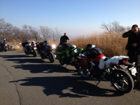
Here we are at the top of the mountain overlooking NYC.

1729533079921.png

Blackbird 1100 / Hyabusa / ZX1100R / CBR250
 

Back
Top Bottom