Which GPS system do you use aside from your phone | GTAMotorcycle.com

Which GPS system do you use aside from your phone

I have a Montana 600 with powered bike cradle and separate car cradle, Ontario backroads maps, North American road maps and satellite overlay. Pricey but it's extremely versatile.
 
Are you riding 100% street, or do you dual sport some?

If street only, I'd get a bike centric gps if your phone doesn't do it for you or you can't make do with a car gps in a waterproof container of some sort.

If dirt and street, then you need the ability to switch to 'direct routing' if you want to follow the tracks provided by others in which case you are likely looking at some sort of Garmin hiking GPS. I use a Garmin Map 78 despite how ugly it is because it has a solid power connect (compared to those with a micro usb charge port), is waterproof, and is not touch screen -- solid buttons respond much more accurately with gloves on than a touch screen does. My biggest complaint is the small screen size, but when I just need to follow a line on a screen it works well.
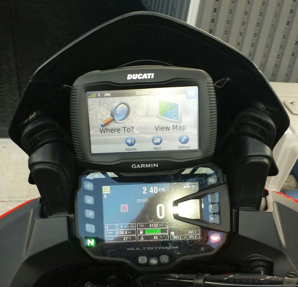
 
Just grabbed a used Garmin 550, off a member here. Loving it. Now hardwired directy to bike, all waterproof.
 
A cheap Nuvi 765 on a ram mount.Ziplock bag waterproofs it when needed.
 
I just use either my old Garmin Nuvi 350 in a RAM mount, or Siri/iPhone in my pocket depending on if I want visual or audio GPS. I want to get a Zumo or TomTom Rider at some point, but just can't justify the cost yet.
 
I use an old Magellan that I used to have in the car. The touch screen responds well to gloves and like someone posted, a ziplock bag over it id there's rain. However, I went this route because I already had it. If I had to purchase one, I would get a motorcycle /outdoor specific one. Wouldn't have to worry about rain, probably more rugged, and I would assume that the screen would be anti-glare. That's probably my biggest complaint. Unless you have/ can make a sun shield.
 
I can recommend a Garmin Zumo 660. Dedicated Motorcycle GPS.(lifetime Maps)

It is glove friendly, waterproof, tough as it has fallen off the bike, glare-free screen and propper marine grade charging mount (not through a USB port)

You can load routes and then adjust them as needed with the device. You can also create routes on the fly with the browse map feature. Bluetooth enabled too.

Expensive yes, but they do go on sale $449 (Costco) as they have been replaced by a newer model. My smartphone does almost everything but it is not a great Motorcycle GPS.

Still a good price considering that an aviation spec Garmin Radio GPS cost $25k. And no you cannot legally use your Iphone to navigate an aeroplane.

If you can find an old Street Pilot pick it up.
 
Last edited:
What is the prob with using iPhone??


Sent from my iPhone using Tapatalk


Data charges. *depending on app
Battery drain.
Glare.
Stone will eff up that screen real good.

My personal issue is that phones are more of a "jack of all trades, master of none" deal. If you will be using it enough, then a dedicated GPS may be a worthwhile purchase.
*imho*
 
My Iphone has a battery problem when using GPS and I can't be bothered to replace it just for the GPS feature. Thanks for the feedback guys
 
My Iphone has a battery problem when using GPS and I can't be bothered to replace it just for the GPS feature. Thanks for the feedback guys
Pick up any cheap/garbage/stolen Android phone/tablet and install Here on it (free, no data required). Hops on random wifi connections to do live traffic but all the maps are stored on your SD card (or internal memory if you have enough). The amoled screens are nice and easy to read in the sunlight and if your gloves are kangaroo you can use them on the touch screen perfectly :)

https://play.google.com/store/apps/details?id=com.here.app.maps&hl=en

Plug your phone/tablet into this to keep it charged as you ride: http://www.aliexpress.com/item/12V-...l-USB-Charger-Blue-LED-Light/32237785097.html
 
Hey Shane, are your maps all up to date? Did you find the new map sets can no longer fit on the internal memory? I had to load them onto an external sd card.
Yeah i actually just upgraded my maps about a month ago from my old 2010 set. I can't remember what I was able to fit on the unit directly, but it might have been only eastern Canada and eastern US. I'm glad the unit has a slot for the external card. What size card did you use and have you had any problems running the new map off the card?
 
I also have a Nuvi 765(t) on a ram mount but I find it's not bright enough for daylight riding. Looking at getting a Zumo 660LM instead. Either way, recommend getting a Garmin product with FREE Lifetime Map Updates.
 
I use my iPhone 5S running Waze attached to my Hayabusa via a Ram Mount X-Grip and stem mount with the audio routed to my Uclear headset.
 
I have the garmin 660LM ordered from GPS city on line. Was here 2 days after ordering it on line. Came with lifetime maps, motorcycle and car mount and knows when you switch it. Hard wired to the bike so never any power issues. Water proof and no data costs. If you like to ride don't depend on your phone, there are so many black areas north and in on the best hiden roads in the USA.

basecamp software is awesome..save all my routes and even mounted my gopro to it...great set up and have never questioned the costs because it's been worth ever penny.
 

Back
Top Bottom