Best Navigation App That Supports Multiple Destinations | GTAMotorcycle.com

Best Navigation App That Supports Multiple Destinations

Boots

Well-known member
Hey Guys, sorry if this has been discussed ad nauseum, I tried searching but couldn't find anything.

I recently did an 8 hour ride but I had mapped it on Google Maps. Since the route had multiple destination points, when I loaded the map on my phone, google maps did not navigate me through the route but instead it allowed me to "Preview" my route after I had reached my first destination point.

It's incredibly annoying and frustrating to have to keep stopping to look at my phone to see if I'm going the right way or even worse play with the phone while riding to make sure I'm still on the right roads. I just want to be able to bring the pre-created route on my screen and look down to find out where to turn to hit my next road without my screen going off.

Is there any mobile app that works best for what I'm trying to achieve? Bonus points if it 1) has an easy to use user interface when creating a map or 1.5) allows me to put in the Google Maps link and it creates the map on that app itself. And 2) Could download offline maps. 2 isn't as important but 1 is super helpful.

Thanks for any help, and sorry again if it's been discussed.
 
I read about Calimoto (calimoto) here on this forum and has been using it ever since.
It does everything I need. It's free to plan shorter routes, but I upgraded it for $90 per year as I think it's worth it IMO.
Try it out and post up what you think.
 
Scenic has proven to be a great nav app in my motorcycle toolbox.

I subscribed for a 1 year plan as motorcycle specific apps are pretty rare to begin with, so it made sense to support them.
I like the ability to not only plot out multi point rides as well as just say "I want to go to such and such place" and then select different route options from fastest to super curvy.
 
Hey Guys, sorry if this has been discussed ad nauseum, I tried searching but couldn't find anything.

I recently did an 8 hour ride but I had mapped it on Google Maps. Since the route had multiple destination points, when I loaded the map on my phone, google maps did not navigate me through the route but instead it allowed me to "Preview" my route after I had reached my first destination point.

It's incredibly annoying and frustrating to have to keep stopping to look at my phone to see if I'm going the right way or even worse play with the phone while riding to make sure I'm still on the right roads. I just want to be able to bring the pre-created route on my screen and look down to find out where to turn to hit my next road without my screen going off.

Is there any mobile app that works best for what I'm trying to achieve? Bonus points if it 1) has an easy to use user interface when creating a map or 1.5) allows me to put in the Google Maps link and it creates the map on that app itself. And 2) Could download offline maps. 2 isn't as important but 1 is super helpful.

Thanks for any help, and sorry again if it's been discussed.
What does Google Maps have in common with the late Walt Disney?


M_I_C_K_E_Y M_O_U_S_E

I use a program called Road Trip Planer (Mac only) to create my own maps.
It uses Apple Maps (Tom Tom) and Open Street Map plus Satellite View.
It allows far more points than Google Maps.
Open Source Maps show paved roads in different colours determined by wether they are multiple lanes or major routes.
You can use Garmin's Base Camp if you don't mind clunky!
After I create my map with POIs marking Tim's, Gas Stations and accommodations I export them as .gpx.
I usually do one day per file.
I then convert them to .kml on Gpx2kml.com: convert gpx to kml online. It's free, simple and fast (free)
I then open the .kml file in a text editor and change each track to the same dark blue colour. https://mapsme.zendesk.com/hc/en-us/articles/210133609-How-to-change-the-color-of-kml-tracks- (free)
As a navigation device I use MAPS.ME ( iPhone, iPad, & Android.) free if you don't want the EXTRA features.
It runs off the GPS chip so no data required.
You download the .kml files you created and can be turned on individually or all on.
When the device is set up you will have an arrow in the middle of the screen and the route will move underneath it.
MAPS.ME will doe its own mapping like a off the shelf GPS devise. It SUCKS.
YES it is a lot of effort but what else have you got to do with snow on ground.
Contact me and let me know your address and I will do up a local map for you to try.

To be fair I use Google Maps Satellite View a lot to check on road condition.
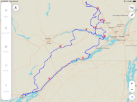
attached is a screen shot of a 3 day trip
 

Attachments

  • Kingston-Mont-Tramblant.png
    Kingston-Mont-Tramblant.png
    739.9 KB · Views: 9
Last edited:
Google can do a lot better to improve its maps’ navigational capabilities but I believe it’s intentional. It’s not positioned itself to be a player in the multi point route navigation. The target market segment is the average tourist or daily router that has 1 or possibly 2 waypoints to their destination.

My biggest gripe with Google map is

1. Limited to 10 waypoints OOB.
2. After each waypoint, you have to press continue to carry on, unlike other players who self continue after the user has passed the waypoint for a km or so.

Good luck trying to continue if riding with gloves that are non touch sensitive! Been there and struggled.

However gmaps sacrifices capbilities over ease of use and performance. I am yet to find a better desktop application that allows me to search and plan a route, the way gmaps does. Gmaps does route planning efficiently, with a beautiful user interface, with an excellent response time to your search query with minimum downtime. Moreover the map itself is quite detailed.

So I would plan a route on gmaps, download a gpx and use a different app for navigation on the motorcycle, ideally.

I completely agree. I don't really understand why they have those limitations, otherwise it would be almost perfect. You can get over the waypoint limit by using this clunky hack:

 
I just did a composite map combining 12 maps into 1 using Road Trip Planer to create a screen shot for another post.
It now contains 185 way points over 5000 km. When converted to .kml and installed into MapsMe gives a non stop route that even crosses itself.
In MapsMe the Points of Interest are clickable and can have text added saying left right or straight thru to clarify crossing paths.
One can also change the colour of the POIs to designate the same thing.
I use a iPad mini as a view screen & with the bigger size touch screen gloves work reasonably well.
With MapsMe you can adjust the size of the portion of the map that is viewing.
The larger the display portion of a map showing gives better view of radius of corners and more advance notice of road changes.
The smaller the display portion of the map showing is better for finding exact address in towns and cities.
I realize scaling can be done in Google Maps but MapsMe does not use any "data".
MapsMe does not use cellular location but uses preloaded maps (free) combined with the GPS chip in you device .
As to the argument that cellular locating is faster than GPS it usually takes les than 30 seconds for the GPS to find your location on startup.
I never turn off MapsMe unless I am off the bike for at least 30 minutes.
Also GPS is not the best in cities with 30 story buildings on both sides of the street but I have no desire to go there anyway.
Neither system works great in tunnels so I suggest "move towards the light".
I do not have a data plan on my phone and buy "as I use" and this usually costs me between $1.00 & $4:00 a month.
Of course I can turn on Cellular Data on my phone if I am in a situation where I really need contact.
 
Last edited:

Back
Top Bottom