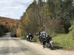
The other day coming home from a ride, I encountered some traffic and had to make a detour. My GPS sent me down this awesome road which turned out to be the Old Nipissing Road. I read up on it when I got home and it turns out it's a historical road which early pioneers and settlers used to use. Some info here: http://www.nipissingroad.ca/
Basically it starts around Rosseau in the south and ends in Commanda in the north.
If you're not scared of a little dirt or gravel mixed in with your pavement, this is a fun road. Apparently the far north section is pretty rough, but still largely passable by a bike or at least with room to turn around if you encounter a section that isn't. I'm going to go and ride the whole length one of these weekends to see what it's like. It's also nice that it goes through the 518 which is just all kinds of awesomeness to begin with.
I haven't been on the whole section mapped here, but have been on a good portion of it and feel it's one of the better runs through the Muskoka's and free of traffic. The paved sections are really nice with endless hills, turns and all kinds of curves. It is generally paved in the south and gets progressively more dirt and gravel moving north, except of the sections just south and north of Magnetawan, where the road reminds me Southwood #13 but more fun, because when it's paved you know what to expect and there are no loose surprises, and same goes for the gravel/dirt portions. Where it's gravel, it is a hardpacked gravel road and same goes with the dirt section... both are not the really loose stuff. The run from start to finish is around 120km (and more if you include the out and back of Orange Valley Road to Broadbent which also looks like a nice and dirty 40km blast).
Avoid when wet because there may be puddles hiding big potholes
Route:


