gps route planning/ waypoints program on a Mac computer? | GTAMotorcycle.com

gps route planning/ waypoints program on a Mac computer?

ice05

Well-known member
Site Supporter
Hi Guys,
Ive tried looking and all I've found are outdated posts or posts that use PC specific programs only. I checked mapsource but it says for PC only and I checked Tyre but it also says PC software and I have a macbook pro...the posts also seem to have just died out without a specific solution for macs...

has anyone here that has a mac computer found a good software that can 1. plan routes 2. be uploaded into a GPS? Thinking of buying the Nuvi 550 if that helps?


Some of the outdated/ related links I found:
http://www.gtamotorcycle.com/vbforu...route-mapping&highlight=waypoint+mac+computer

http://www.gtamotorcycle.com/vbforu...8&highlight=waypoint+mac+computer#post1254198

http://www.gtamotorcycle.com/vbforu...&p=1562821&highlight=gps+waypoint#post1562821
 
Install VirtualBox, create a VM Windows computer. I do this on Linux.
 
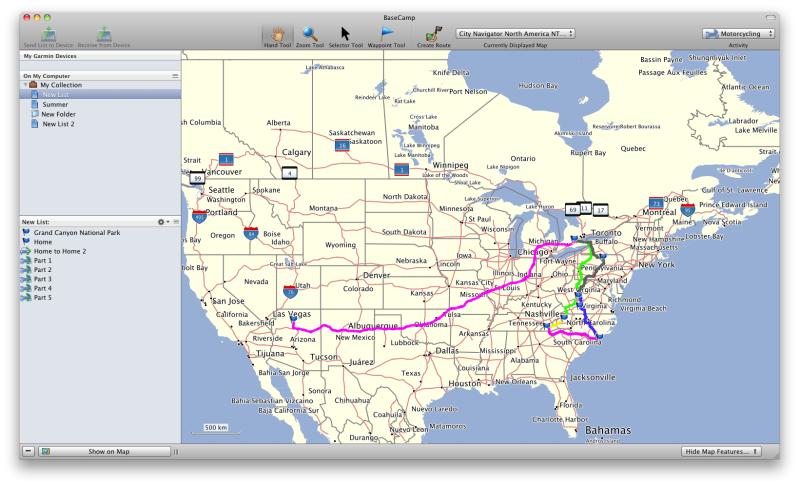
Basecamp, its in the App store, its by garmin for garmin.

Screenshot2011-07-25at84319AM.png


I have my maps loaded on that, but it will also use your Garmin when plugged in. I plot my route out in Basecamp, it has all the POI's and such, then send to my GPS.
 
There is a Mac specific page for software on the garmin site . It includes RoadTrip and POI loader.

Also, there are some third party applications - open source- which are great too. I often use Google maps and then export the route to GPX format. There are tips online on how to do this.
 
Last edited:
There is a Mac specific page for software on the garmin site . It includes RoadTrip and POI loader.

Also, there are some third party applications - open source- which are great too. I often use Google maps and then export the route to GPX format. There are tips online on how to do this.

If you have a garmin GPS, whats the benefit of using other software other then Garmins? Garmin Basecamp is in the app store and is free, you just need to supply the maps.
 
Install VirtualBox, create a VM Windows computer. I do this on Linux.

I have parallels 6 and have a virtualbox but its a bit of a pain and it also slows down my computer :S I will try the basecamp hopefully itll work...

If you have a garmin GPS, whats the benefit of using other software other then Garmins? Garmin Basecamp is in the app store and is free, you just need to supply the maps.

sorry if it seems like a dumb question but what do you mean supply the maps? would google maps do or I have to purchase separately?
 
I have parallels 6 and have a virtualbox but its a bit of a pain and it also slows down my computer :S I will try the basecamp hopefully itll work...


sorry if it seems like a dumb question but what do you mean supply the maps? would google maps do or I have to purchase separately?

If you buy a new garmin, you get the maps from that, so you will be set. All you need is basecamp, then just buy a garmin gps and your ready to go.
 
thanks will try this! now its just a matter of deciding between a "regular" garmin vs a "motorcycle" friendly nuvi 550...(cant afford the zumos)...do you guys have a zumo or 550 or a regular gps on the bike?
 
thanks will try this! now its just a matter of deciding between a "regular" garmin vs a "motorcycle" friendly nuvi 550...(cant afford the zumos)...do you guys have a zumo or 550 or a regular gps on the bike?

On my last bike, R1200GS, I have a Zumo 550. For my new bike R1200GSA, I will be putting a Zumo 660 on it. Decent screen size, some nice features I like for riding, such as showing me a few turns coming up, rather then needing to look right away once the turn is made, plus its waterproof which is a must.

A cheaper route is the Nuvi 550, its what I got my dad for his Harley. Its waterproof and much cheaper then the Zumo, $219
http://www.gpscentral.ca/products/garmin/nuvi550.html

You would just need to buy a mount and cradle for the bike, as well as the wiring to power the gps from your bikes battery.
 
I've all but given up using Roadtrip. I lay out my routes using Google Maps copy the link and use http://www.gpsvisualizer.com to convert to a GPX file which I copy to my Nuvi.

again sorry if its a newb question but when you plot it out do you use google maps's point A B and C then copy the link to gpsvisualizer?

Is there any way to add waypoints straight on gpsvisualizer or just add a bunch of points on google maps then import?
 
Last edited:
again sorry if its a newb question but when you plot it out do you use google maps's point A B and C then copy the link to gpsvisualizer?
Yes, I lay out the entire route then take the link from Google Maps and let GPSVisualizer do its voodoo and save as a .GPX file which I copy to the Nuvi.

Is there any way to add waypoints straight on gpsvisualizer or just add a bunch of points on google maps then import?

There is an option to paste your data (name, description, lat, long) into gpsvisualizer and it will do the conversion to .GPX. Similar format to making POI's for Nuvi's. Tried it but it was too much work copying all the lat/long into a text file. I let Google map the route from start to finish and then click and drag the route along roads I want to travel on. If you have a Google account My Maps in Google Maps gives you more mapping options i.e. Place markers, different route colours. It will also allow you to use Google maps prepared by others.
 

Back
Top Bottom