I apologize, it’s been a while since I’ve been active on GTAM. Way back, the on-street motorcycle parking fees fight got me involved, now the Ganaraska issue is the cause that’s bringing me back.
So what’s happening – the short version:
The Forest re-opened on September 30th with less than 7% of the total amount of trails open. That included no single-track. Even though much of the forest and trails are still closed, existing annual memberships that were purchased with the expectation of using the whole of the Forest (as allowed by use), were extended to expire 1 year later. So if you purchased in July 2021, and your membership ran until July 2022, it now runs to July 2023, but with no commitment to when and how much of the forest will be open by that time.
GRCA staff are using the May 21st storm as an “opportunity to improve recreational trail systems”, and by “improve”, they mean “result in the permanent closure of certain Forest areas, access points and trails to recreational users”.
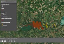
Their new mapping shows a new category in the legend called GFC Recreational Boundary, which is smaller than the lands that were open prior to the storm.
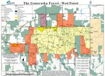
The lands in red and purple in the West Forest are being permanently closed to all recreational use
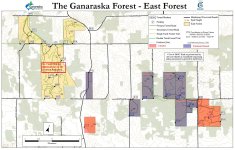
The lands in red in the East forest are being permanently closed to all recreational use. The lands in purple are now “passive” use, i.e. no motorized, and anyone without at least a G1 or M1 licence (including anyone under 16) can’t ride in the remainder of the East Forest.
The reopening protocols also stated that “the only access points into the Ganaraska Forest are parking lots P2 (West Forest) and P5 (East Forest).” “There is no off-road vehicle/dirt bike municipal road access to the Ganaraska Forest. All ORV and dirt bikes must be trailered to official access points.” “There is no trail connection between the West Forest, Central Forest and East Forest.”
And if you think that’s bad, it gets worse! Staff have admitted that “Single track trails for any use are currently challenging and near impossible for the GRCA to create and manage”. Lately, staff have identified “the existence of unofficial trails” as a problem, and are “developing a plan to implement restructuring”. Even before this plan is developed their immediate response includes “GRCA has removed all unofficial trails from current GRCA mapping” and “all trails infringing on GRCA neighbourhoods, do not meet GRCA standards or are unauthorized by municipal rules will be blocked and/or signed as closed”. “GRCA standards”, whatever they are, have not been published. Coincidentally, small woodland creatures have been reporting that the old Honda and OFTR single trail markers are being removed. It will be interesting to see how much, if any, single-track is opened when the Forest re-opens at the beginning of May.
None of this has been taken by staff to the GRCA Board for approval, even though the Forest Management Plan, which sets the long term management and strategic direction for the forest through to 2038, specifically states “road and trail closures will only be implemented when and if there are public safety concerns between harvest operations and users. Other trail closures will only occur when ecological attributes of the forest are being significantly impacted by continued trail use.”
 www.ganaraskaforestcentre.ca

