2025 - Ride to West Coast

shanekingsley

Curry - so nice it burns you twice
Site Supporter
In 2024 I was lucky enough rent a bike and ride the California coast from San Diego to San Fran, so now I'm planning a trip to ride the northern half between Seattle and San Fran. And I've also always wanted to ride to Cali and back (instead of flying and renting a bike), so hoping to finally knock this one off my list in 2025.

I'm doing this on a 2002 FZ1.

My wife is doing the Ottawa Ironman on August 3, so after cheering her on, I can do this ride from Aug 9 onward. If all goes well, she can fly out and meet me in Seattle around Aug 15 to ride the Cali coast together to San Fran, and then she flies home.

I can take at least 23 days to do this trip and possibly 30 days. I figure some days of riding across the mid-west will be higher mileage days (+1000km), while riding the coast 2up will be much lighter days (~500km), so maybe I'll average around 700-800km/day. Right now the route is around 14,500km and it will likely get longer since I typically like to avoid the slab and take backroads. It would be pretty neat to ride 21 states in 21 days.

I'll probably do the motel thing to save space on packing the tent and gear, but I'm still undecided since I can save a fair bit of coin by tenting and I really like moto-camping. At least I have all the moto-camping gear if needed.

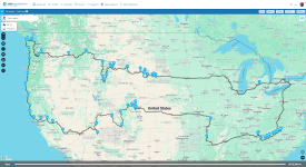
Along the way there I'd hit up Mt Rushmore, Needles Hwy, Devil's Tower, Bighorn, Yellowstone, Beartooth, Chief Joseph, Glacier, Mt Rainier and Mt St Helens.
Coming home I'd plan to ride through Yosemite, Death Valley, Zion, Bryce Canyon, Grand Canyon North Rim, Arches, Moab, Million Dollar Highway, Ozarks and maybe the Smokies and the Blue Ridge Parkway/Skyline.

If anyone has any tips for must ride roads/areas along the way - I'm open to all suggestions, including if there are any must ride mountain roads between Seattle and San Fran.
If anyone wants the GPX file once it's roughly mapped out, just let me know and I'm happy to share it.

Here's the constantly updating route:)
1734801173102.png
 
Last edited:
Sounds like a great plan, i did the north western part of your plan last June. riding from Rapid City SD through Colorado, UT, Mo, Wy and then back to Rapid City (2 weeks with bikes trucked to Rapid City)

Was a big group of us with a loose plan of using motels and camping but ended up using Cabins quite frequently and probably could have left the tents at home if you are looking so save some space.
 
WOW. fantastic ride.
Can't give you any advice as you are the one that I am often asking for advice.

I wish I had the time to do at least half of this ride.

Fingers crossed, I hope to rent a bike for a day or two on a Europe trip next year.
 
Sounds fantastic. Try to see Yosemite NP if you can. That place is magical. Don’t hit Yellowstone on the weekend. If you can incorporate Hwy 14A in Wyoming from Dayton to Cody since you will be in the area. Very nice views and road. Alway good to see signs on that say closed in winter.
 
Last edited:
Looks like a great trip.

I thought I heard Blue Ridge Parkway/Skyline might have been under construction, possibly finished by now. I'm sure you have this kind of info researched anyway.
 
30 days would be awesome.

I'd love to do a trip like this in that sort of timeline (although knowing me, I'd be home early lol), but the thought of taking almost all my vacation all at once and then having to go ~11 months at work without any more time off, ugh, that'd suck. I like to spread out my time off, typically never taking more than 2 weeks at a time to maintain my sanity lol.
 
Mount St Helens is worth seeing.
Thanks and added - looks perfect and pretty much right on the way.

Sounds fantastic. Try to see Yosemite NP if you can. That place is magical. Don’t hit Yellowstone on the weekend. If you can incorporate Hwy 14A in Wyoming from Dayton to Cody since you will be in the area. Very nice views and road. Alway good to see signs on that say closed in winter.
Thanks and already have Yosemite included on the way home and will avoid the weekend.

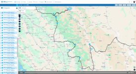
Heading west from Dayton, I was going to take the northern route via the 14Alt like this: Dayton to WY-120
Is it more worthwhile to veer south on the 14 like this instead? Dayton to 52-46 WY-296

Looks like a great trip.

I thought I heard Blue Ridge Parkway/Skyline might have been under construction, possibly finished by now. I'm sure you have this kind of info researched anyway.
Thanks for the reminder and I'll be checking that for sure - hoping that a lot of the BRP closures in the south will have been fixed up by next summer if I do go that route.

30 days would be awesome.

I'd love to do a trip like this in that sort of timeline (although knowing me, I'd be home early lol), but the thought of taking almost all my vacation all at once and then having to go ~11 months at work without any more time off, ugh, that'd suck. I like to spread out my time off, typically never taking more than 2 weeks at a time to maintain my sanity lol.
Yeah doing this over 4 weeks would be so much nicer than blasting through in 2-3 weeks. For once on a moto trip, I want to get off the bike and walk around. Every day from South Dakota onward I want to walk or hike for at least an hour or two each day. If it slows my pace down then I'll be enriched for it. It's just a matter if I can skip out on responsibilities at home for that long in one shot.

Because I took very little time off in 2024 and am finally getting credited with some of the extra work I do, I finally have the luxury of taking up to a month for this while still having some time off if I want it elsewhere in the year. Still want to squeeze in trips to Guyana and Peru in 2025:)
 
Heading west from Dayton, I was going to take the northern route via the 14Alt like this: Dayton to WY-120
Is it more worthwhile to veer south on the 14 like this instead? Dayton to 52-46 WY-296
I was heading East from Cody and took 14A to Dayton. I didn’t go south on 14 so can’t say. One of the locals told me that 14A was a way more fun ride. I was there at the end of May many years ago. and there was snow over 8’ high on the sides near the top at the observatory.
My avatar pic was taken on that road.
Perfect and thanks! I'll keep it just the way I had it then.

Also added in Death Valley and the Grand Canyon north rim.
 
Is Sequoia National Parkon the route?? Should be straight forward to hit it from Death Valley and then Yosemite if you plan your route carefully. The road from the east up to Sequoia is wildly twisted - you'll love it. You might have difficulty finding the route coming directly from the east but pretty sure it can be found instead of having to loop. Our brakes on the little Toyota were just about smoking by the time we came down from locking ourselves out of the car almost ( lucky we had a sunroof ) at 12c and running gear on then getting from 9,000' in Sequoia to below sealevel in a straight run. I'm sure there is a way to cut nearly straight across but I recall it was difficult to find - we were coming west to east.
These are the sensible routes...I KNOW there are back road twisties cutting across.
Screen Shot 2024-12-22 at Dec, 22    2024    6.19.00 AM.jpg

🤪 Fit and happy in our late 20s ...
Taking a morning run in Sequoia is a total treat - you feel realllllly small.
My then wife told me just a couple years ago she considered our hike in and out of the Grand Canyon on the same the day the hardest physical task she ever undertook - I was surprised as she was national class athlete/champion in downriver kayaking. It was certainly my hardest day.
So if you are intent on hiking ......
The National Park Service does not recommend hiking from the rim of the Grand Canyon to the river and back in one day. The hike is challenging and dangerous, and the Park Service rescues hundreds of people each year who attempt it and can't make it back out
Can you hike to the bottom of the Grand Canyon and back up in one day?
17 miles. 10,000 feet of elevation change. One day. As soon as my husband, Louis, learned from a friend that it's possible to hike from the rim of the Grand Canyon down to the Colorado River and back up again in a single day, he was completely on board
Cresting the final few feet to the rim and throwing ourselves on the grass is forever embedded in my memory even some 50 years later.
 
I won't hike or go to the bottom of the Grand Canyon. My folks used to spend their winters in Sedona/Cottonwood for 10 years, so I've been to that whole south side a fair bit. I've also been to the south rim and stayed at Bright Angel before, so this time I just wanted to see the north rim from the top. Short hikes only!

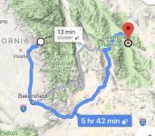
I didn't have Sequoia in there because I couldn't figure out how to get to it from the east. But thanks for the reminder to look at it more, because I really want to check it out and added it in anyways from the west by doing an out 'n back over the Tioga Pass. Something like:
1734819641995.png
 
Back
Top Bottom